FRONTIER FERTILIZER
A FEDERAL SUPERFUND SITE IN EAST DAVIS
| [ Homepage ] [ Background ] [ Current Status ] [ Future Plans ] [ Newsletters ] |
CURRENT STATUS
The contamination in the groundwater moves in three water-bearing zones containing sand and /or gravel separated by clay aquitards. The two shallow zones (S1 and S2) are 10 to 20 feet thick and within 90 feet of land surface. A third, deeper water-bearing zone, the A1 aquifer, lies between 110 and 130 feet below land surface. The contaminated groundwater flows horizontally from 50 to 500 feet per year depending on agricultural and municipal pumping, seasonal climate changes, and other factors.
Contaminated groundwater has continued to spread despite installation of and upgrades to the groundwater extraction and treatment system. The current pump and treat system is not sufficient to completely contain the plume at present. Lateral migration of the contaminant plume does appear to have slowed during the last two years however. The current system, even though upgraded, was always intended as a temporary system, and was never meant to be the final solution. EPA and its current contractor, CH2MHill, are designing an expanded and permanent extraction system that includes larger capacity extraction wells both close to the original site and in the vicinity of homes overlying the plume.
EPA and its contractor have recently finished a series of groundwater and soil samplings to determine current levels and extent of soil and groundwater contamination. Recent data show that, while contaminant concentrations are apparently decreasing somewhat in the upper two groundwater-bearing zones, contaminant concentrations are increasing in some locations in the A1 aquifer. High concentrations of contamination also remain in the shallow groundwater-bearing zones and in soil near and underlying the original disposal pits. During its investigations, EPA also found that the removal system was not fully operational for the some of the past year.
Complex factors affect contaminant movement and capture. These include pumping from the aquifers, climate, and on the nature of soils and aquifer materials. Starting in March and continuing through August, growers throughout the region pump groundwater for irrigation. This pulls water down from the shallow groundwater zones and causes downward movement to the A1 aquifer and deeper. This probably accounts for at least some of the downward movement of contamination into the A1 aquifer from the upper water-bearing zones.
This apparent downward movement is of concern to the FFSOG. If unchecked, continued downward movement of contaminants could eventually endanger the city's main drinking water aquifer, the A2. Also, though nearby city wells are probably not currently at risk, about a mile northwest of the site, city well 22 at Slide Hill Park intercepts the A1 aquifer. Groundwater in the A1 moves toward this well or away depending on climate and other pumping. Large volumes of water flow in the A1. While this is good in the sense that contaminants are diluted, it can also allow movement of contaminants toward this city well. Another city well, well 29 in Mace Ranch is much closer, but it pumps water from much deeper in a lower aquifer and is unlikely to be affected by the contaminants. Even though dilution and pumping from deeper in the aquifer decrease the probability of serious contamination entering the city's water supply, the contaminated groundwater cannot be allowed to continue either vertical or lateral migration. (The city does monitor all its wells for contaminants.)
EPA has recently defined the extent of high concentrations of contaminants in groundwater in the vicinity of the "source area" in the region of the old disposal basin and in the other high-concentration area in the vicinity of Arroyo and Caricia in the Mace Ranch neighborhood north of the site (see map). Data show that contaminant concentrations in the S2 in a small area just north of the former disposal basin are as high as 1 million times the EPA drinking water standard. Data also show contaminant concentrations in other areas in the S1 and S2 as high as 30,000 times the EPA drinking water limits. In the S1 and S2 in the vicinity of Arroyo and Caricia in Mace Ranch 11, EPA measured concentrations as high as 620 times the EPA drinking water limit. Water from these two zones is not used for irrigation or drinking. In the A1, the highest contaminant concentration recently detected was 1000 times the EPA drinking water limit. This aquifer is used for irrigation but not for drinking water. The solvent carbon tetrachloride (CCl4) is also present in the groundwater and at concentrations as high as 240 times drinking water limits in the area immediately north of the Frontier site and 50 times the drinking water standards in some areas in the groundwater underlying the Mace Ranch neighborhood north of the site. Concentrations of contaminants are at or below EPA drinking water limits in most of the groundwater underlying Mace Ranch 11, and none of this water is pumped for drinking.
In summary, the contamination in the groundwater has continued to spread both vertically and horizontally despite upgrades to the pump and treat system. As mentioned above, this was an interim system. EPA is currently expanding the system and working toward a final remedy for removal or treatment of contaminated groundwater and soil, including determining locations for more extraction wells to expedite removal and for a system to transport contaminated water to the treatment facility on the Frontier site.
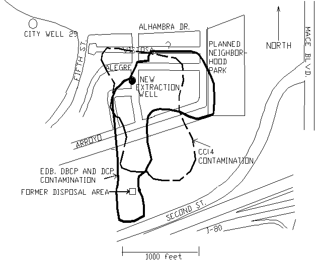
Approximate extent of contamination. Dashed line delineates where carbon tetrachloride exceeds the maximum permissible drinking water concentration. Solid line delineates where pesticides exceed the maximum permissible drinking water concentration. Question mark indicates extent of contamination is unknown.
For informataion regarding the Frontier Site or the FFSOG contact Pam Nieberg.